Wilderness Hiking
Menu
  • About
  • Quebec
    • Capitale nationale
    • Eastern Townships
    • Lanaudière
    • Laurentides
    • Montérégie
    • Montreal
  • Adirondacks (NY)
    • List of High Peaks
    • High Peaks (Blog)
    • List of Fire Towers
    • Fire Tower (Blog)
    • Lean-to
    • Rules and Guidelines
  • White Mountains (NH)
    • Presidential Range
  • Tips & How To

Adams Mountain


By Richelle | August 11, 2015 | Category Adirondacks (NY), Fire Tower, High Peaks


The Region : High Peaks, Adirondacks (NY)
Start Location : Upper Works Road (Many other trail heads alon this road) – Big parking lot
Altitude: 1073 m (3520 ft)
Ascention : 548m (1800ft)
Distance from start : 6.4km (4.8miles) round trip
Height rank : 87
Parking : Parking lot
Trail Markings : Red & Yellow DEC Markers
Toilet : At the start
Weather Conditions : At Lake Placid (NY)
Dates : 2016-04-21 with Richelle, Ben R. & André B.

This was one of the beautiful trails I did. There aren’t many viewpoints but the one at the top is worth 10 regular ones!

This is one of the firetower hikes. The firetower is maintained and you can climb it.

The start

After a long road to the parking lot (took us over 3 hours), you finally make it!

On Upperworks road, you will pass by an abandonned iron mill (or something like that).  It’s about 2 minutes from there.

The start is the same as Allen Mountain and many other trails in that sector. The parking is gigantic. You can’t miss it.

In the middle of nowhere USA, there are signs in french.

In the middle of nowhere USA, there are signs in french.

The first 2 km of the trail are very easy. A relaxing stroll in the woods. You will find a beach, a bridge that can also be used as a trampoline and remnants of the old bridge, which couldn’t be used as a trampoline.

Tiny beach before the bridge.

Tiny beach before the bridge.

Once you’ve done this 2km you will arrive at the ranger’s cabins.

Abandonned rangers cabin in the woods

Abandonned rangers cabin in the woods

This cabin was the HQ of the ranger who took care of the fire tower. This tower was not only used to inform the population of forest fires but also used as a lookout for airstrikes during the war (whichever war).

At this point, it’s not obvious where you have to go! Keep going a little. The trail becomes big enough for some All Terrain Vehicles and soon after, you will see the intersection for the Adams Mountain Trail.

Hard to find intersection

Hard to find intersection

Now it gets interesting!

The ascent

You are now walking up Mount Adams on a steady ascent, steep and rocky at some places, to the top.

This lasts for about 2 km where you will have ascended about 600m. Our cardio was put to the test!

The summit

You can’t even imagine! I am posting pictures but it is nothing to living it for yourself!

The wind is very strong on top of the fire tower where we stopped to enjoy our victory beer!

I was able to ID the peaks using my map and a beautiful drawing on a table in the fire tower ID-ing many summits.

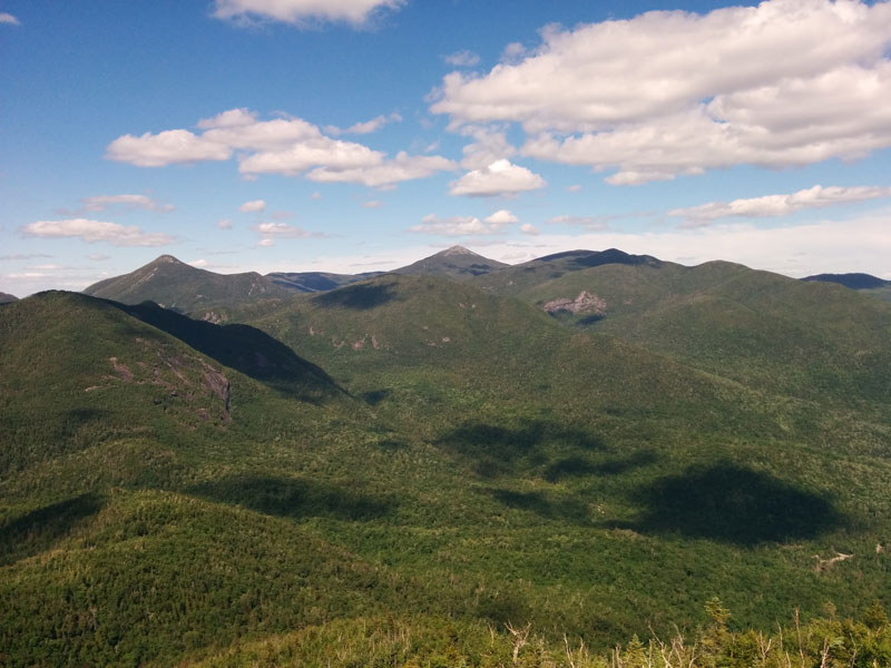
You have a 360 view on the giants of the High Peak region!

The fire tower

The fire tower

Stantinoni Mountains view from the summit of Mount adams

Stantinoni Mountains view from the summit of Mount adams

Vew from the summit of Mount adams on the Highest Peaks!

Vew from the summit of Mount adams on the Highest Peaks!

We headed down the steep mountain and chilled a little at the beach before heading home.
Initially we wanted to hike up Poke-O-Moonshine (easy fire tower hike) afterwards but the road was way too long and we arrived too late.
Just this hike was reward enough. I highly suggest it!

Happy Hiking!

Leave a Reply Cancel reply

Your email address will not be published. Required fields are marked *

Recent Posts


  • Sept Chutes Regional Park
  • Cap-Saint-Jacques Park
  • Morgan Arboretum
  • Poke-O-Moonshine
  • Saint Adolphe D’Howard Trails
  • Mont Rougemont
  • Mont Durocher – Sainte Adèle
  • Les Sentiers Brandon
  • Mont Kaaikoop
  • Hautes-Gorges-de-la-Rivière-Malbaie National Park

Pages


  • About
  • Adirondacks
  • Fire Tower

Tag Cloud


adirondacks Agriculture app beach bike camping capitale-nationale dogs allowed eastern townships fire tower fishing free high peaks hike hiking tips lake lanaudière laurentides lean-to legend Montreal montérégie park path explorer ravine refuge river rules & guidelines stream summit swamp SÉPAQ waterfall white mountains winter hiking

Categories


  • Adirondacks (NY)
    • Fire Tower
    • High Peaks
    • Lean-to
    • Rules and Guidelines
  • News
    • Potential Trails
  • Quebec
    • Capitale nationale
    • Eastern Townships
    • Lanaudière
    • Laurentides
    • Montérégie
    • Montreal
  • Tips & How To
  • White Mountains (NH)
    • Presidential Range

Recent Posts

  • Sept Chutes Regional Park
  • Cap-Saint-Jacques Park
  • Morgan Arboretum
  • Poke-O-Moonshine
  • Saint Adolphe D’Howard Trails
  • Mont Rougemont
  • Mont Durocher – Sainte Adèle
  • Les Sentiers Brandon
  • Mont Kaaikoop
  • Hautes-Gorges-de-la-Rivière-Malbaie National Park

Tag Cloud

adirondacks Agriculture app beach bike camping capitale-nationale dogs allowed eastern townships fire tower fishing free high peaks hike hiking tips lake lanaudière laurentides lean-to legend Montreal montérégie park path explorer ravine refuge river rules & guidelines stream summit swamp SÉPAQ waterfall white mountains winter hiking

Pages

  • About
  • Adirondacks
  • Fire Tower

Categories

  • Adirondacks (NY)
    • Fire Tower
    • High Peaks
    • Lean-to
    • Rules and Guidelines
  • News
    • Potential Trails
  • Quebec
    • Capitale nationale
    • Eastern Townships
    • Lanaudière
    • Laurentides
    • Montérégie
    • Montreal
  • Tips & How To
  • White Mountains (NH)
    • Presidential Range

Copyright © 2015 Wilderness Hiking

Theme created by PWT. Powered by WordPress.org