Wilderness Hiking
Menu
  • About
  • Quebec
    • Capitale nationale
    • Eastern Townships
    • Lanaudière
    • Laurentides
    • Montérégie
    • Montreal
  • Adirondacks (NY)
    • List of High Peaks
    • High Peaks (Blog)
    • List of Fire Towers
    • Fire Tower (Blog)
    • Lean-to
    • Rules and Guidelines
  • White Mountains (NH)
    • Presidential Range
  • Tips & How To

Hautes-Gorges-de-la-Rivière-Malbaie National Park


By Richelle | October 6, 2016 | Category Capitale nationale

Region : Capitale Nationale(Qc)
Start : Camping du Pin Blanc (For the Acropole des Draveurs Trail)
Distance from start : 10.86km
Parking : Parking lot
Fee : $8.50/person
Trail Markings : Horribly identified
Difficulty : Hard
Washroom: At the reception desk
Map : Full Park Map
Website : Sepaq Official Website
Notes : Bus takes you from the reception to the trail starts & Campgrounds
Date of hike : 2016-07-25 • 10.86km  (Richelle, Ben R., André B., Gabrielle P.)


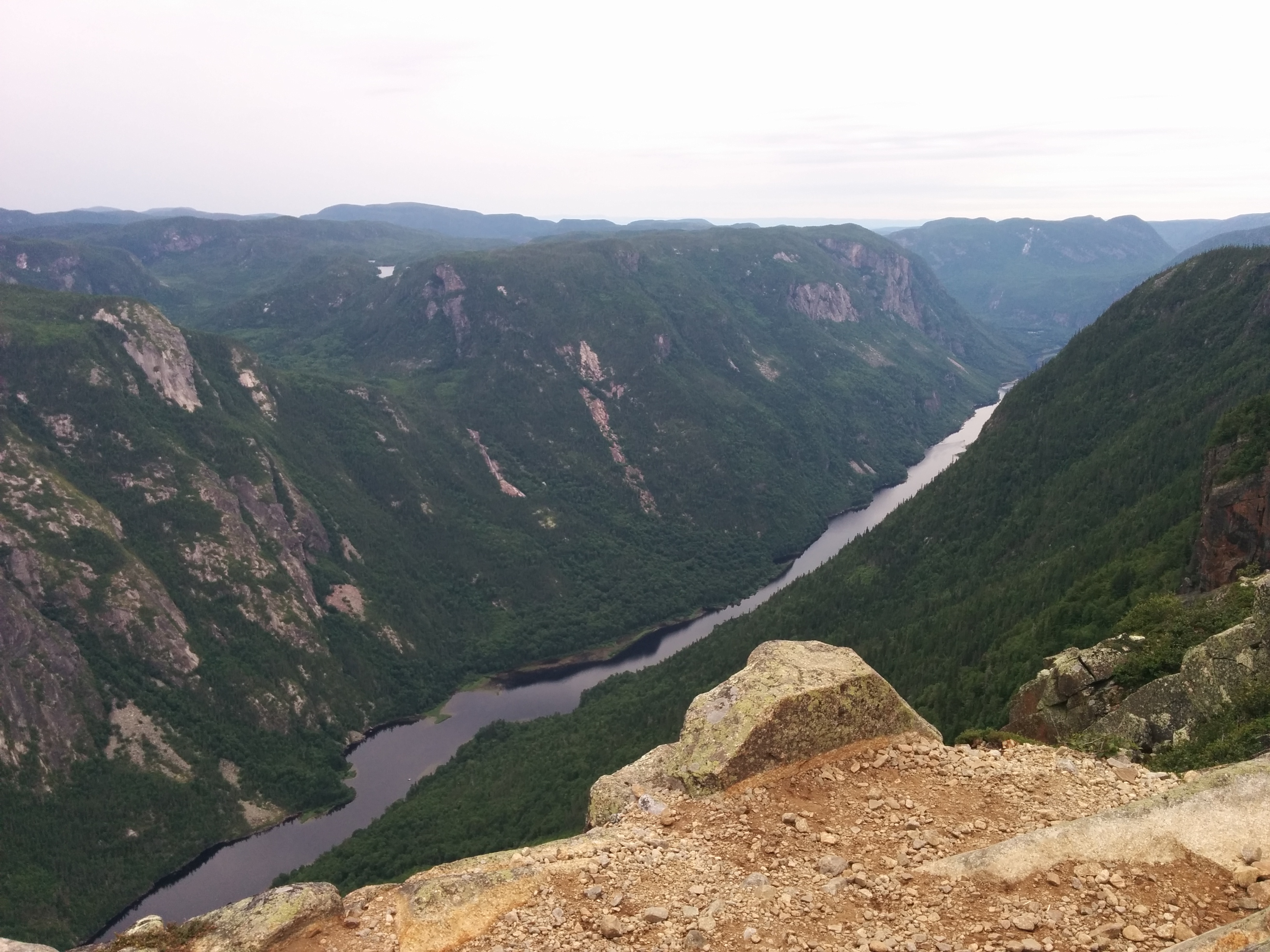
There are many hikes available in this park but the one everybody is talking about is L’Acropole des draveurs.

This is one of the most beautiful summits in Quebec. You have a view on where the raftsmen would send the woodthat the loggers cut during the summer down the river.

Unfortunately for us, it POURED from the moment we arrived at the summit (just enough time to take some pictures) well into the night.

You will start at the reception building where there is a bus that takes the hikers to the start of the trail.

The hike is a steep way up to the top.

There are 3 summits, all close together, who give amazing views on the valley.

Trail Difficulty Km Ascention Start / Note
L’Érablière Easy 2,5  km 20m Pont des Érables (km 2) – View point
Le Belvédère Easy 0,4 km 55m Barrage des Érables (km 8) – Easy Viewpoint on the valley
Le Pied-des-Sommets Easy 0,5 km (loop) 35m Barrage des Érables (km 8) – Viewpoint on Mont Félix-Antoine-Savard
La Chute-du-Ruisseau-Blanc Easy 1 km 78m L’Équerre (km 16) – viewpoint on a water fall
Le Riverain Intermediate a) 21,2 km 160-170m a) CDS
Le Riverain Intermediate b) 20,4 km 160-170m b) Camping du Cran (km 0,5)
Le Riverain Intermediate c) 17,4 km 160-170m c) Pont des Érables (km 2)
Les Rapides Intermediate 15,2 km round trip 20m Camping Le Cran – Bike/Hike trail
L’Acropole-des-Draveurs Hard 11,2 km round trip 800m Camping du Pin blanc – Viewpoint on the Valley – Legendary Hike


Happy Hiking

Tags: camping, capitale-nationale, hike, summit

Leave a Reply Cancel reply

Your email address will not be published. Required fields are marked *

Recent Posts


  • Sept Chutes Regional Park
  • Cap-Saint-Jacques Park
  • Morgan Arboretum
  • Poke-O-Moonshine
  • Saint Adolphe D’Howard Trails
  • Mont Rougemont
  • Mont Durocher – Sainte Adèle
  • Les Sentiers Brandon
  • Mont Kaaikoop
  • Hautes-Gorges-de-la-Rivière-Malbaie National Park

Pages


  • About
  • Adirondacks
  • Fire Tower

Tag Cloud


adirondacks Agriculture app beach bike camping capitale-nationale dogs allowed eastern townships fire tower fishing free high peaks hike hiking tips lake lanaudière laurentides lean-to legend Montreal montérégie park path explorer ravine refuge river rules & guidelines stream summit swamp SÉPAQ waterfall white mountains winter hiking

Categories


  • Adirondacks (NY)
    • Fire Tower
    • High Peaks
    • Lean-to
    • Rules and Guidelines
  • News
    • Potential Trails
  • Quebec
    • Capitale nationale
    • Eastern Townships
    • Lanaudière
    • Laurentides
    • Montérégie
    • Montreal
  • Tips & How To
  • White Mountains (NH)
    • Presidential Range

Recent Posts

  • Sept Chutes Regional Park
  • Cap-Saint-Jacques Park
  • Morgan Arboretum
  • Poke-O-Moonshine
  • Saint Adolphe D’Howard Trails
  • Mont Rougemont
  • Mont Durocher – Sainte Adèle
  • Les Sentiers Brandon
  • Mont Kaaikoop
  • Hautes-Gorges-de-la-Rivière-Malbaie National Park

Tag Cloud

adirondacks Agriculture app beach bike camping capitale-nationale dogs allowed eastern townships fire tower fishing free high peaks hike hiking tips lake lanaudière laurentides lean-to legend Montreal montérégie park path explorer ravine refuge river rules & guidelines stream summit swamp SÉPAQ waterfall white mountains winter hiking

Pages

  • About
  • Adirondacks
  • Fire Tower

Categories

  • Adirondacks (NY)
    • Fire Tower
    • High Peaks
    • Lean-to
    • Rules and Guidelines
  • News
    • Potential Trails
  • Quebec
    • Capitale nationale
    • Eastern Townships
    • Lanaudière
    • Laurentides
    • Montérégie
    • Montreal
  • Tips & How To
  • White Mountains (NH)
    • Presidential Range

Copyright © 2015 Wilderness Hiking

Theme created by PWT. Powered by WordPress.org