Mount Washington
Region : Presidential Range / White Mountains(NH)
Start Location : Pinkham Notch: Directions/Website
Distance from start : 8.4m (13.5km) to 10.8mi (17.4km)
Ascention : 3800ft (1150m) to 5000ft (1500m)
Altitude: 6288ft
Parking : Parking lot/Free
Fee : Free
Trail Markings : At intersections + Totems at top
Difficuly : Hard
Maps :
Weather :
Transportation :
- Suttle to Trail Heads & Key lodging spots : Schedule
- Shuttle to & from Summit : Schedule & Pricing
- Round Trip to summit by train : Website / Brochure
- Hitchhiking is prohibited!
Notes :
- Dogs allowed
- Winter Hikes available but can be very dangerous. This blog article doesn’t cover this topic.
- Tourist attraction
Date of hike :
September 12, 2015 (Richelle, Ben R., André B, Gabrielle P. & Friends) : Tuckerman’s Ravine Trail Up & Lion Head Trail Down
Table of Contents :
At the moment that I am writing this, this is the biggest hike that I’ve ever been on. You can be geared up and in shape, but nothing prepared us mentally for this.
We stayed at a motel randomly selected by our trip organizers (it wasn’t even us, what a treat!!!) in Gorham (NH), the Moose Brook Motel, where we had a comfortable stay in beautiful, well kept rooms for 2 nights at a very reasonalbe price. There even is a pool but, at that altitude, in september, we didn’t use it.
Before starting, make sure to buy a Map of the Trails and to consult the people at the Pinkham Notch center about trail conditions. If the weather isn’t safe, don’t go!
Tuckerman’s Ravine Trail
We started off by heading to Pinkham Notch. At 9:15, after prepping the whole team, buying maps & chilling at the chalet, we were on the trail, starting our ascent. This is way too late to start if you plan on climbing down!
I highly suggest starting earlier, to avoid the crowds and to have all the time in the world for breaks.

A 3D model of the trails of Mt Washington at Pinkham Notch
Even though this trail is considered the “easiest”, don’t be fooled! You still need to be in shape to do this. The road is hard and very rocky.
As you probably have read on other blogs, the first 2.4miles (3.9km) up are of intermediate level. You are hoping along rocks and still manage about 1970 ft (600m) elevation. This got me warmed up for what was coming up.
Just before reaching the ravine, there are many services available : Lean-to/refuges that rent for the night, nice real toilets, a service area with tables to eat and a water station!
After this, the real fun begins. You get a steady yet more vertical climb up where you finally get a glimpse of the views to come.
This doesn’t last very long and then you climb up the steep ravine wall! The wildlife here starts to change and is as breathtaking as the views. Because of the little streams flowing down the ravine, there is lichen and wild flowers all around! Don’t forget to look to your left to see the view revealing itself to you.

The view when ascending Tuckerman’s Ravine
Once you’ve climbed the ravine, you start the painful ascent to the top. This is the hardest part of the hike! Jumping from boulder to boulder, thinking about where to put your foot next, it’s like going up stairs that are higher than your knees. According to my Sports Tracker app, we were going up at 0.6mi/hour (1km/hour), which I consider slow for an ascent.
At this point, you are hiking your ass off but don’t forget to take in the view!

Just before the grueling ascent to the summit… we’re still smiling at this point 🙂
The Summit/Crawford Path
At one point, you start to see cars and, lets face it, this is probably the only time I was happy to see a car along a trail.
The summit is… interesting… just try to ignore the insane amount of people around you.
Since we were pressed in time, we didn’t go see all of the attractions. We started off by “hiking” up the stairs to the end of the Crawford path. Even though this path is short, it’s humbing to know that you took some time to go on the oldes continuously maintained footpath in the USA (1819 by Abel Crawford and Ethan Allan).
As we arrived, a huge cloud came by and hid the view. We took a pit stop at the Sam Adams building, where there is a cafeteria with pizza, hot dogs, hot chocolate (with marshmallows) & coffee.
There is also the weather observatory, where the crowds will gather to witness the worst weather on earth!
This is also the end of the line for the Cog Wheel Train

Cog Wheel Train at Mount Washington Summit. Choo Choo!
After having rested up, we headed back for the trails…
Lion Head Trail
The Lion Head trail is as long as Tuckerman’s Ravine, a little bit at some parts and a lot more rewarding.
I would only suggest going down this trail because of the part just before entering the woods.
After the steep descent from the summit, you will take a left at the Tuckeman/Lion intersection and continue for another steep path.
Once this is over, you will find yourself on one of the plateaus, with low vegetation and a breathtaking view of 180°! This goes on for a while and it took all of my energy to think of looking down at where i’m putting my feet.

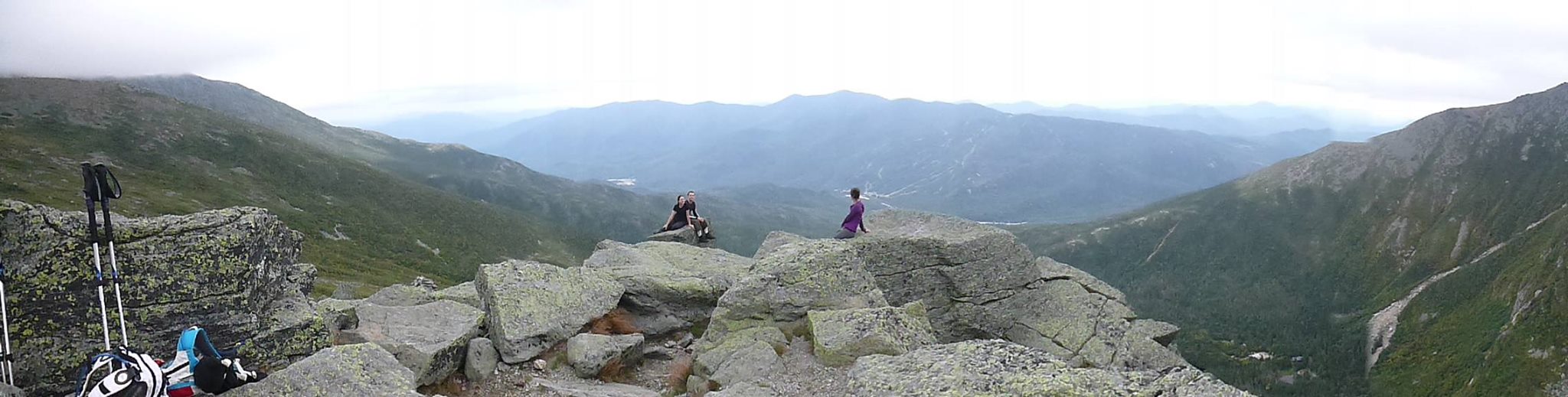
Lion Head Trail

Panorama of the Lion Head Trail
After the view points and inspiration, we headed into the woods for the continuation of the steep ascend down. The trail is as rocky as Tuckerman’s. I think we had a whole 3m of walking on soil in the whole treck down!
The trees grow higher and eventually, you are back in the mossy forest.
Take a left at the Tuckerman intersection and remember that you are only half way down!
Some of our group had bad shoes so this last section, the slow descent on a rocky road, was finished in the dark. We were the only ones with a head light for the group so this part took us forever!
We finished in 12 hours (regular time : 9hrs-ish)!!!
Future projects
In the coming years, depending on our budget, I would like to return for the Ammonoosuc Ravince and Jewell Trail Loop.
This trail is longer than the one we did this time but my plan would be to stay at the Lake of the Clouds Hut, just before the Washington Summit and check out the Eisenhower and Monroe Summits as well!
Pinkham NotchPinkham Notch
| Route | Miles | Km | Elevation (ft) | Elevation (m) | Start |
|---|---|---|---|---|---|
| Round trip by Tuckerman’s Ravine | 8,4 | 13,5 | 4300 | 1307,2 | Pinkham Notch |
| Round trip by Lion Head | 8,4 | 13,5 | 4300 | 1307,2 | Pinkham Notch |
| Round trip by Boott Spur | 10,8 | 17,4 | 4300 | 1307,2 | Pinkham Notch |
| Loop, Boott Spur and Tuckerman’s Ravine | 9,6 | 15,4 | 4300 | 1307,2 | Pinkham Notch |
| Round trip by Ammonoosuc Ravine | 9 | 14,5 | 3800 | 1155,2 | Marshfield Station |
| Round trip by Jewell trail | 10,2 | 16,4 | 3800 | 1155,2 | Marshfield Station |
| Loop, Ammonoosuc Ravine and Jewell trail | 9,6 | 15,4 | 3800 | 1155,2 | Marshfield Station |
| Round trip by Great Gulf | 15,8 | 25,4 | 5000 | 1520 | |
| Loop, Great Gulf and Tuckerman’s Ravine | 12,1 | 19,5 | 5000 | 1520 | |
| One way Crawford Path | 8,5 | 13,7 | 4750 | 1444 | Marshfield Station |
The average annual temperature : 27.1°F,
Summit Max Temperature : 72°F
Maxium Wind Speed : 231 mph (World Record from 1934)