Mont-Mégantic National Park
Region : Cantons de l’est (Qc)
Start :
• Observatory : Centre de découverte
• Franceville : Franceville sector Reception
Distance from start :
• Franceville : 15km
• Observatory : 17km
Parking : At the reception
Fee : 8.50$/day – National parks fee
Trail Markings : SEPAQ Trail Markings
Difficulty : Easy to Hard
Washroom: At the Refuge & Summits (See map)
Map :
• Mont Mégantic – Franceville Sector
• Mont Mégantic – Observatory Sector
Website : Parc national du Mont-Mégantic
Date of hike : 2016-09-05 (Richelle C., Benoit R., Marie-Michèle G., Joannie O.)
Note :
- Star Sancuary – Observatory open at night for StarGazing activities until beginning of september. call to make sure.
- Beautiful refuges with locked rooms – Climb up with your gear and then leave it there to hike around lighter
I’m grateful to have had the motivation to make the 3 hours dive down to this Park. Since we wanted to make it worth our time, we tackled the 17km – 3 summit trail.
You will go to Saint-Joseph Mtn, Victoria Mtn and Mégantic Mtn Summit in that order.
Since Mégantic is the highest and the trail form the summit to the reception is easy, I suggest finishing with this one. It’s always fun to finish a long hike on an easy descent to make you feel super strong!
Saint-Joseph Mountain Ascent
This trail starts at the reception. You are quickly confronted to a constant hard ascent through a magical fern forest. Hope you weren’t too burnt out from the long drive!
There are a couple of nice viewpoints along the way up.

Obligatory panoramma picture at the first view point
Saint-Joseph Summit
The summit of this mountain is impressive. This place is simply beautiful!
There is a chapel, a giant cross and religious statues. Even though I’m not religious, I still appreciate the beauty of what the pilgrims built.
The only issue that most hikers will have with this area is that it is accessible by car, meaning that there is a ton of people taking pictures and getting their non-hiker asses in your own pictures that, lets face it, after a hard hike like that, you feed entitled to!
The non-hikers usually take up all the piknik tables, because they have to constantly be sitting down and don’t know the virtues of a good long hike. 😉
Enough ranting… along with the show.

Saint Joseph Mtn Summit

Saint Joseph Mtn Summit
The view is spectacular! Luckily, there is a pannel Identifying the major mountains. I took the liberty of making my own version.

Mont Saint Joseph Summit View with Cliff ID
Mount Victoria “ascent”
At this point, the map given to you at the reception starts to become ridiculous… Don’t follow it!
The map indicates that there is a viewpoint 300m & 1km away while the summit is at 1.8km.
The only viewpoint is 1km away, at the belvedère.
Lucky for you, all the hikes on Mt Victoria are very easy. There are some of the piknik people from Saint-Joseph that wandered into the woods in their sandals and didn’t seem to be inconvenienced.
We ate at the belvedère which had a nicer view than Victoria summit. I still suggest going to the summit to have bragging rights over doing the three summits.
The belvédère offers a view on the Mont Mégantic Observatory…. which looks so far away it’s impossible to make it before nightfall. Spoiler : We made it WAY before nightfall.

Mont Mégantic Observatory seen from Mount Victoria
Mont Mégantic Ascent
This is a long hike in the woods witout many viewpoints. Lucky for you, the fern/lichen forest has a magical feel about it.
You go down Victoria and up Mégantic but not in the scary giant valley that you saw from Mt Victoria. I would consider this trail of intermediate difficulty.
Mont Mégantic Summit
The wood trail to the summit ends abruptly at the asfalt road. Look back and you will see Mt Joseph and Victoria in the distance. This is when we knew that we were way too tough to kill!
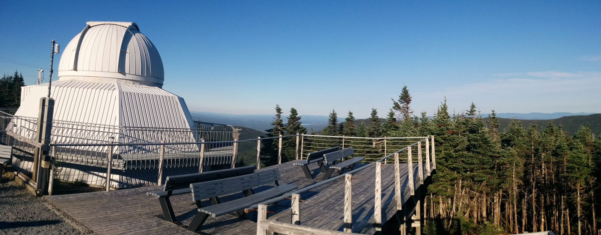
The observatory is also accessible by car but there were a lot less people than at Saint-Joseph.

St-Joseph and Victoria Mtn in the distance… you walked all of this!!!!
If you made it up to here, it’s time that I reveal the BIG SECRET about Mont Mégantic Observatory….
…
…
There are acutally TWO observatories!
Mind Blown!

Mont Mégantic Observatory
Mont Mégantic Descent
The 5km descent starts off at intermediate difficulty as there are rocks and roots everywhere but it eventually eases out and your last 2.5-3 km go by fast and easy on a nice gravel road.
We arrived at the car at sundown. Tired, hungry and proud!
This hike was definetly worth the trip.
Happy Hiking