Wilderness Hiking
Menu
  • About
  • Quebec
    • Capitale nationale
    • Eastern Townships
    • Lanaudière
    • Laurentides
    • Montérégie
    • Montreal
  • Adirondacks (NY)
    • List of High Peaks
    • High Peaks (Blog)
    • List of Fire Towers
    • Fire Tower (Blog)
    • Lean-to
    • Rules and Guidelines
  • White Mountains (NH)
    • Presidential Range
  • Tips & How To

Sept Chutes Regional Park


By Richelle | October 24, 2017 | Category Lanaudière

Region : Lanaudière (Qc)
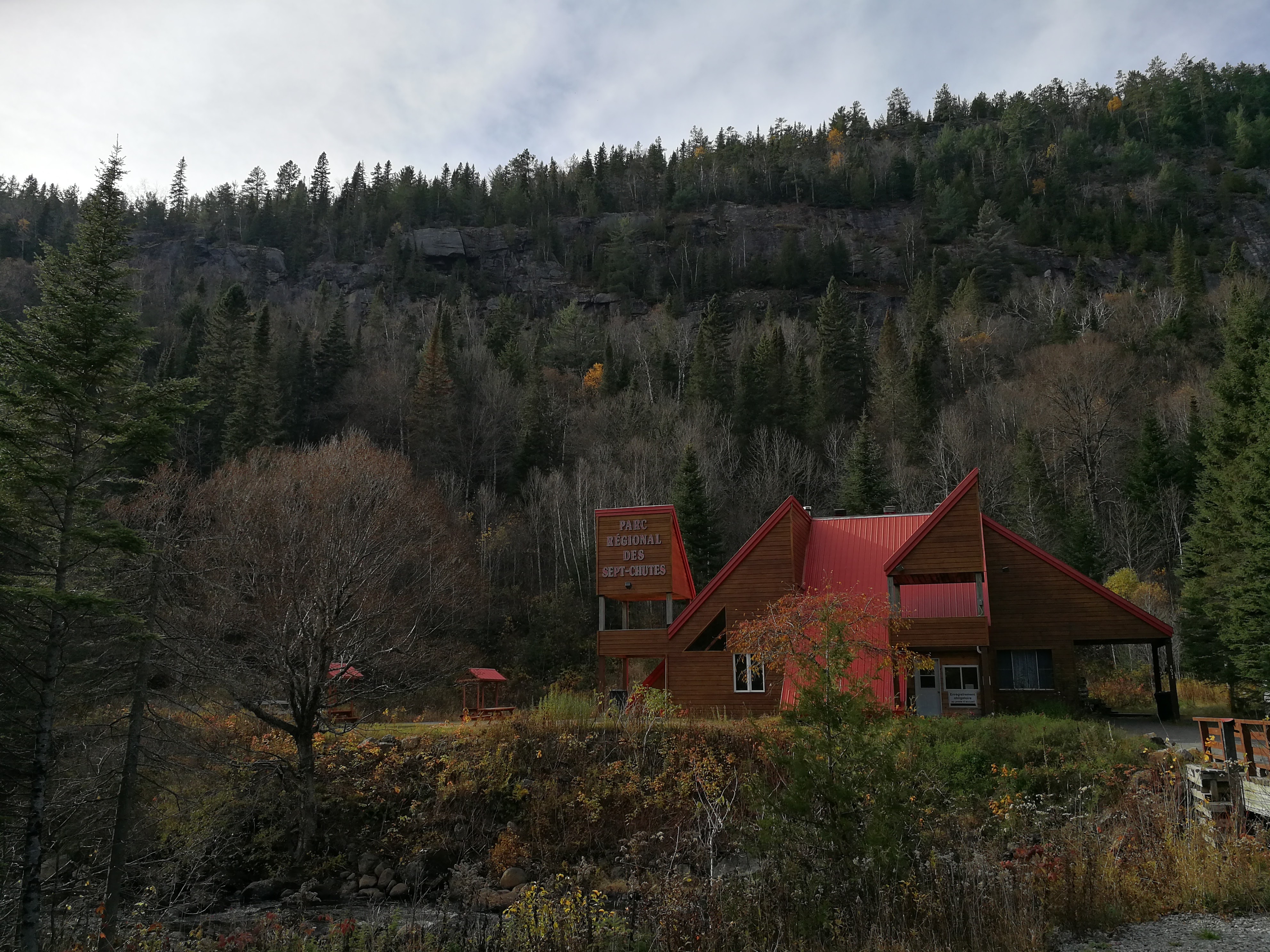
Start : At the reception
Distance from start : 23km
Parking : Yes
Fee : 6$
Trail Markings : Well identified
Difficulty : Easy to Intermediate
Washroom: Along the trail/Marked on the map
Map : Full park map
Website : Parc regional des sept chutes
Weather : Weather Conditions
Date of hike : 2017-10-24 (Richelle, Ben R.)
Note : Connects to Sentier National de la Matawinie

The start

Everybody starts at the reception where you have to pay the entry fee. The “Voile de la mariée” trail leads to the intersection where you can connect to the other trails.

Last year we came here with two dogs and they weren’t able to make it 1km. The trail has big rocks and the dogs were not ready for this kind of hike (1h30 of driving for nothing…ugh).

Along the trail, there are a couple of viewpoints tocheck out the 60m waterfall. It’s so big that you can’t see it all in one place.
Once you get past these rocks that are a lot easier for humans than for dogs, you will arrive at Lac Guy, where you will choose which trail to take.

Rocky beach at the Parc Régional des Sept Chutes #matawinie #hiking 🍂☀️😎

A post shared by Richelle Cloutier (@hiking_richelle) on Oct 24, 2017 at 10:10am PDT


In our case, we wanted to try something new so we went for the Lac Rémi trail, which doesn’t lead to a summit.

Lac Rémi (Blue trail)

This trail doesn’t have any elevation but gives priceless views on the cliff on the other side of the lake.

On the map, there is a sign noting that you can rent canoes from one of the beaches. There weren’t any available for our end-of-fall hike but they should be there during the hot summer days.

We also picked this trail to check out the campgrounds. There are 4 sites (2 individual and 2 connected). Each site has a wood base for your tent, a camping table, fire place and direct access to the lake (where you park your rented canoe!).


Awesome view of the cliff from the beach🍂⛰ #fallcolors #matawinie

A post shared by Richelle Cloutier (@hiking_richelle) on Oct 24, 2017 at 10:33am PDT

By the end of the blue trail, we had some energy left but the sun was about to set. We went back to the car.

I would suggest this park for anybody who wants to spend some time in the woods but who doesn’t necessarily need a challenge. This park would be a lot more fun in the summer months where you can take long breaks on the beach, swimming and canoeing in the lake.

Happy Hiking!


Trails

Trail name Color Km Time (Approx Difficuly Note
Voile de la Mariée red 2 1 hour Intermediate Along the River, 60m waterfall
Mont Brassard pink 6,7 3 hours Intermediate 7 vue points/rocky summit
Mont Brassard avec raccourci pink 5,2 2 hours Intermediate 5 vue points/rocky summit
Mont Barrière Orange 6,7 3 hours Intermediate 4 view points/Forest hike
Michel Sokolyk Yellow 3,8 2 hours Intermediate Hike up in the forest
Lac Rémi Blue 4,9 2 hours Easy Along Lake Rémi/Small Beaches

Chillin by the cascade🌊🍂 #hiking #deepinthought

A post shared by Richelle Cloutier (@hiking_richelle) on Oct 23, 2017 at 2:48pm PDT

Tags: beach, camping, dogs allowed, hike, lake, lanaudière, waterfall

2 thoughts on “Sept Chutes Regional Park”

  • Kate says:
    November 6, 2017 at 12:55

    Wow such great information on here! I always struggle with finding new places to hike when I am in a new place because the options are endless. Glad I found your blog!

    Reply
    • Richelle says:
      November 12, 2017 at 12:21

      Hi Kate. Thanks for your comment. I’m glad you like my website and that it’s helpful. 🙂
      Did you try this hike out yet?

      Reply

Leave a Reply to Kate Cancel reply

Your email address will not be published. Required fields are marked *

Recent Posts


  • Sept Chutes Regional Park
  • Cap-Saint-Jacques Park
  • Morgan Arboretum
  • Poke-O-Moonshine
  • Saint Adolphe D’Howard Trails
  • Mont Rougemont
  • Mont Durocher – Sainte Adèle
  • Les Sentiers Brandon
  • Mont Kaaikoop
  • Hautes-Gorges-de-la-Rivière-Malbaie National Park

Pages


  • About
  • Adirondacks
  • Fire Tower

Tag Cloud


adirondacks Agriculture app beach bike camping capitale-nationale dogs allowed eastern townships fire tower fishing free high peaks hike hiking tips lake lanaudière laurentides lean-to legend Montreal montérégie park path explorer ravine refuge river rules & guidelines stream summit swamp SÉPAQ waterfall white mountains winter hiking

Categories


  • Adirondacks (NY)
    • Fire Tower
    • High Peaks
    • Lean-to
    • Rules and Guidelines
  • News
    • Potential Trails
  • Quebec
    • Capitale nationale
    • Eastern Townships
    • Lanaudière
    • Laurentides
    • Montérégie
    • Montreal
  • Tips & How To
  • White Mountains (NH)
    • Presidential Range

Recent Posts

  • Sept Chutes Regional Park
  • Cap-Saint-Jacques Park
  • Morgan Arboretum
  • Poke-O-Moonshine
  • Saint Adolphe D’Howard Trails
  • Mont Rougemont
  • Mont Durocher – Sainte Adèle
  • Les Sentiers Brandon
  • Mont Kaaikoop
  • Hautes-Gorges-de-la-Rivière-Malbaie National Park

Tag Cloud

adirondacks Agriculture app beach bike camping capitale-nationale dogs allowed eastern townships fire tower fishing free high peaks hike hiking tips lake lanaudière laurentides lean-to legend Montreal montérégie park path explorer ravine refuge river rules & guidelines stream summit swamp SÉPAQ waterfall white mountains winter hiking

Pages

  • About
  • Adirondacks
  • Fire Tower

Categories

  • Adirondacks (NY)
    • Fire Tower
    • High Peaks
    • Lean-to
    • Rules and Guidelines
  • News
    • Potential Trails
  • Quebec
    • Capitale nationale
    • Eastern Townships
    • Lanaudière
    • Laurentides
    • Montérégie
    • Montreal
  • Tips & How To
  • White Mountains (NH)
    • Presidential Range

Copyright © 2015 Wilderness Hiking

Theme created by PWT. Powered by WordPress.org